Return to the Frank Passic
Any photos not otherwise credited are from the personal collection of Frank Passic, Albion Historian.
|
Morning Star, January 16, 2026, pg. 3 One particular occurrence during this time was the official subdividing and platting of land in the vicinity of the Babcock School along 25 1/2 Mile Road southwest of Albion. Around 80 acres of land there mostly north of D Drive South was owned by William A. Schultz (1860-1942), and continued by his son Perry Schultz (1892-1978). Their land was subdivided into mostly 1-acre lots in the 1940s. A revised map dated May 1, 1949 by surveyor Roy F. Barry exists entitled, "Plat of Babcock School Area." It gives the names of the new property owners in each parcel. Several years later however, a new plat map (again drawn by Roy F. Barry) was prepared showing the aforementioned parcels being subdivided into half or three-quarter-acre parcels. This was entitled the "Supervisor's Plat of Schultzville" and the project was coordinated by Albion Township Supervisor Donald Sweeney (1895-1972). Dated January 20, 1956, this was an official map approved by the Albion Township Board of Supervisors on February 21, 1956; the Calhoun County Plat Board on March 13, 1956; and by the Calhoun County Road Commission on July 31, 1956. On today's plat maps, this subdivision won't show individual owners and lots, but instead will have a boxed in area with diagonal lines and labeled "Supervisors Plat." On this 1956 map I noticed a couple of peculiarities. They concern a couple of roads that were added and the names given to them. Today's Hill Road in Babcock is an "L" shaped road that goes east from 25 1/2 Mile Road, then makes a sharp right turn headed south to D Drive South. On the 1956 plat map however, Hill Road is identified as Sweeney Road, named after the Albion Township Supervisor. Furthermore, the "L" portion headed south to D Drive South is named Belcher Road. What the story is how these got changed into Hill Road, I don't know, but could it be that the Supervisor tried to name a road after himself? I also noticed that what is D Drive South today was labeled "Schultz Road." In the 1950s Calhoun County began standardizing road names into what they are today, and Schultz Road became D Drive South in Calhoun County. Whatever the case, the name "Schultzville" didn't "take," and people still refer to this little village as Babcock, named after pioneer settler Amos A Babcock (1806-1893), namesake of Babcock School. From time to time, the Calhoun County Road Commission has posted signage along the road approaching this community, which simple stated "BABCOCK." Unfortunately, these signs have always been stolen. and thus, Babcock remains signless today. From our Historical Notebook this week we present a portion of the 1956 "Supervisor's Plat of Schultzville," showing Sweeney Road and various lots with their measurements, and the title portion. How many of our readers have driven through Babcock/Schultzville lately? Special thanks to Frank Reynolds for providing our map this week. 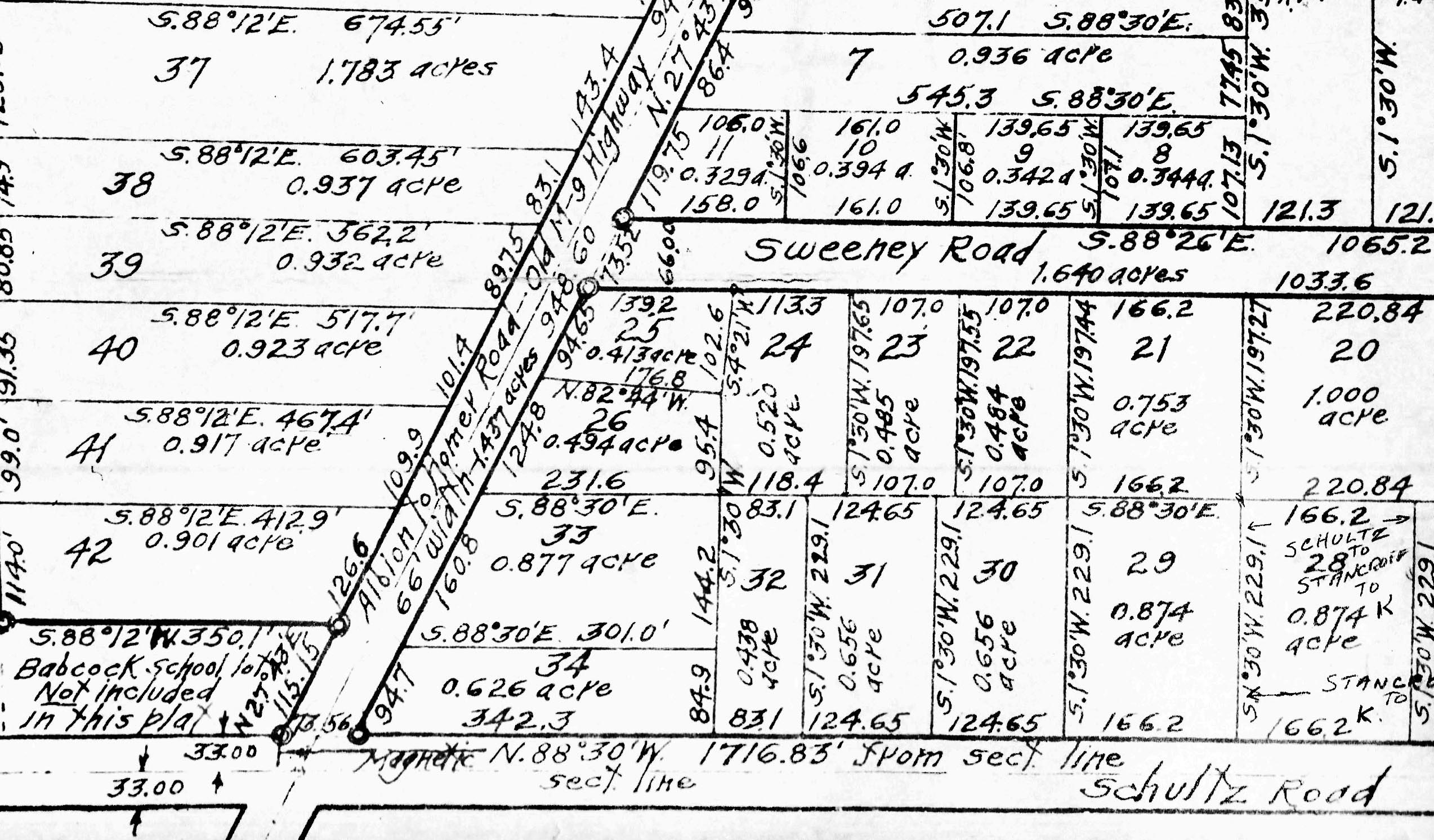 1956 "Supervisor's Plat of Schultzville"
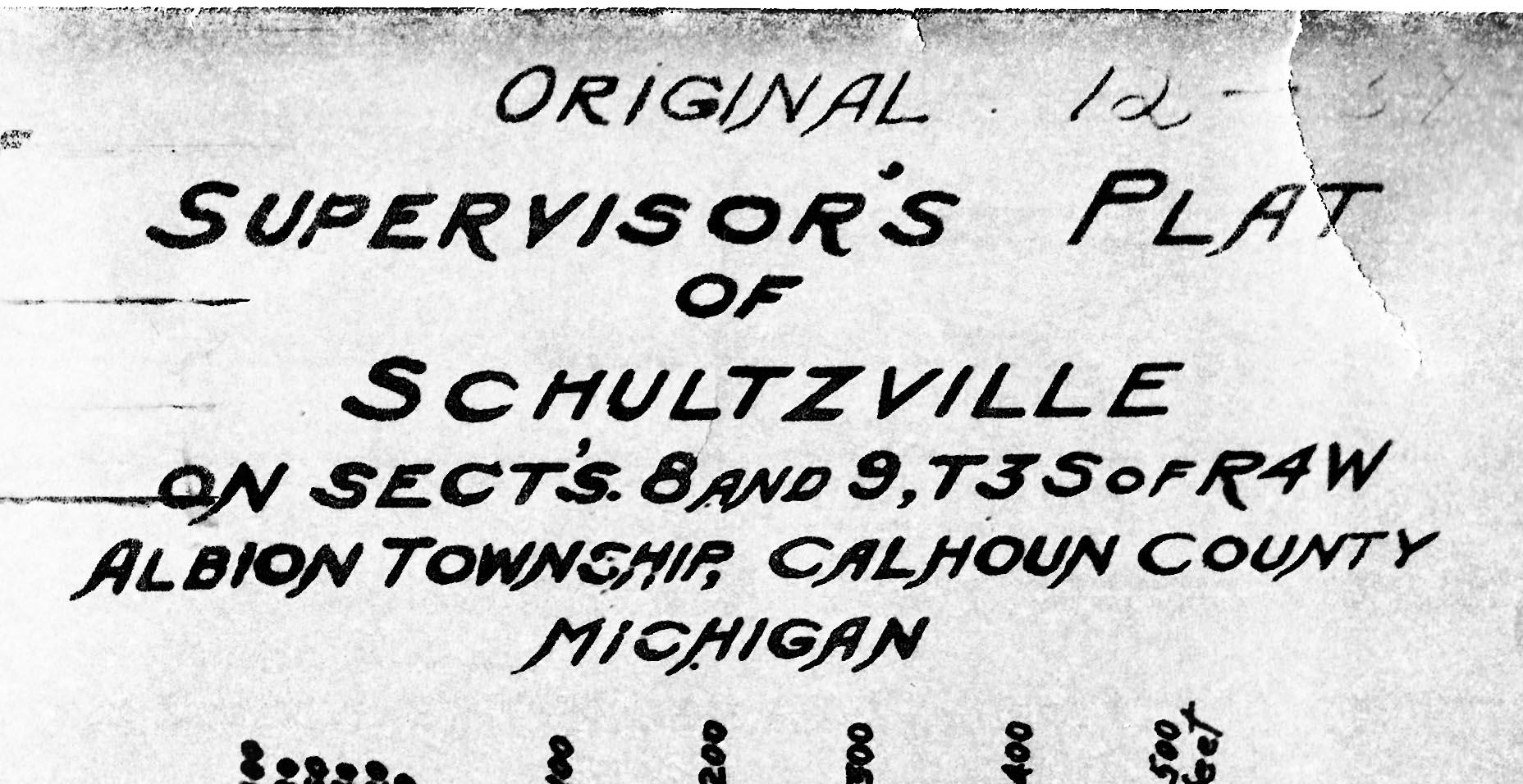 The title portion
All text copyright, 2026 © all rights reserved Frank Passic | Artwork copyright Maggie LaNoue © 2026
| |